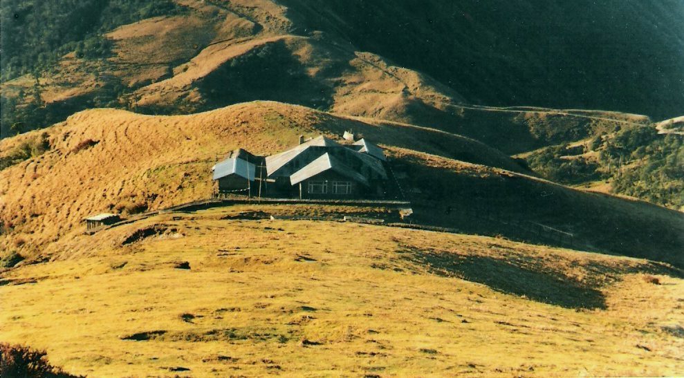
 The Sandakphu
 is the culminating point of many trekking routes in the Darjeeling-Sikkim region.
At an altitude of 3,636 m, it is located at a distance of 58 km. from Darjeeling. Maneybhanjan, at an altitude of 2134 m., is the gateway to the Sandakphu-Phalut region. Trek to Sandakphu starts from Maneybhanjan, a small town. - can be reached from Siliguri via Ghoom or via Mirik.
Sandakphu is resplendent with the ethereal beauty of magnolias, rhododendrons, primulas and other sub-alpine flowers. It also contains more than 600 varieties of orchids. Sandakphu may be visited at any time of the year. The monsoon months of July-August is not suggested. Phalut may be avoided in winter.
Description of the trek to Sandakphu

The first lap till
Chitre
passes quite steeply uphill on a good stoned path through lush greenery
of pine, fir, birch forests and bamboo glades. It takes about an hour
and half to reach
Chitre (2530 m). Crossing the Buddhist settlement of Chitre reach
Meghma. The trail bifurcates at Meghma. The right uphill route leads to the trekkers hut at
Tonglu (3070m) in India. The trail in the left passes through Nepal. The roads meet again at
Tumling (in Nepal).
Tonglu is famous for the view of the snow-capped peaks of the Singalila range and the Kanchenjunga range. Tumling on the other hand
is a salubrious night halt with assorted lodges dotting its sedate
green environs. The lights of the towns of Darjeeling, Kurseong,
Pasupati, Siliguri and other settlements can be viewed in a clear night.
The next day's trek from Tonglu or Tumling is rewarded with a wide variety of flora, fauna and avifauna as you enter the Singalila National Park.
The trek route passes through the Indo-Nepal border. The area is also
the house of wide varieties of Rhododendron and the playing ground of Red Pandas. Reach Goiribans (9 km. 2621 m) through Joubari (in Nepal). After some break move on to second nights halt at Kalepokhri (4 km from Goiribans, 3108 m, in Nepal).
The trek from Tumling to Kalepokhri takes about 5 hours. At Kalepokhri
there is a small crystal lake surrounded by pine trees and prayer flags.
The dark color of the water in the lake leads to the name of Kalepokhri (Kale = Black & Pokhri = Lake).
As the third day of trek unfolds, you realise that Sandakphu is within a short striking distance now (9 km app) leaving behind Bikevanjan(5 Km from Kalepokhri).
But hold your breath. You will be negotiating with an uphill climb
today. After a tough trek will leave you panting and gasping, you will
reach Sandakphu (3636m), the highest point in West Bengal. As soon as you reach Sandakphu, you will realise why it is called the paradise of trekkers. The views of four of the five highest peaks in the world.... Everest, Kanchendzonga, Makalu and Lhotse
along with numerous other snow capped peaks great us in the morning. A
day's halt at Sandakphu allows trekkers to view the surroundings.
From Sandakphu there are several trekking options available to the tourists. You can go down to Rimbik directly by a shortcut route through dense forests via gurdum & Sreeekhola.
Phalut (3600m) 27Km from Sandakphu leaving behind Sabargram. From Phalut you can go Three ways. One is going down to Rimbik via Sabargram & Molley, another is Going down to Rimbik via Gorkey & Rammam. Rimbik is the road head on the other side of the trek. From here you will be taken to your next destination. With the Third way you can reach utture at Sikkim by crossing the Singalila Pass.
Trek path of Sandakphu - Phalut


 other 4 are Kedarnath, Madhmaheshwar, Rudranath, and Kalpanath.
  Aware of Shiva's annoyance, the Pandavas built the temple to please
Lord Shiva and for their own salvation. Others claim that the Adi
Shankaracharya during his historic visit to the region had got it built.
The cite the presence of Adi Shankaracharya's image in the garbha-griha
or the sanctum of the temple. However, it also houses
images of the Pandavas. Besides, the ashtadhatu images of Kaal Bhairava
and Veda Vyasa are among the multitude of images there. A dark
left-tilting one-foot high linga is the centre of attraction. The locals
describe it as an arm of Lord Shiva.
Aware of Shiva's annoyance, the Pandavas built the temple to please
Lord Shiva and for their own salvation. Others claim that the Adi
Shankaracharya during his historic visit to the region had got it built.
The cite the presence of Adi Shankaracharya's image in the garbha-griha
or the sanctum of the temple. However, it also houses
images of the Pandavas. Besides, the ashtadhatu images of Kaal Bhairava
and Veda Vyasa are among the multitude of images there. A dark
left-tilting one-foot high linga is the centre of attraction. The locals
describe it as an arm of Lord Shiva. 
 Chandrashila
peak is another 1 km trek from Tunganath. one can climb the
chandrashila peak from Tungnath as it is in the same feature and can be
reached in about an hour's
time The peak provides a rare panoramic view of innumerable snow peak.
The trek passes through forests of Rhododendron and alpine meadows. If
heading towards Ukhimath one should not miss Deoriatal, now jeepable
from Mastura.
Chandrashila
peak is another 1 km trek from Tunganath. one can climb the
chandrashila peak from Tungnath as it is in the same feature and can be
reached in about an hour's
time The peak provides a rare panoramic view of innumerable snow peak.
The trek passes through forests of Rhododendron and alpine meadows. If
heading towards Ukhimath one should not miss Deoriatal, now jeepable
from Mastura. It is a small deep lake at an altitude of 2440m. In early morning, the snowy ranges including Chaukhamba and Kedarnath is clearly reflected on the water; an unforgettable sight.


 From Bagdogra or New Jolpaiguri lolegaon is nearly 140 km away by Car.


 Description


 The plumage is gray with a distinctive black cap with a fallen
crest of two to three narrow white plumes at the back of the head. The heron has
a black back and the face, throat, fore neck and belly are white.
The plumage is gray with a distinctive black cap with a fallen
crest of two to three narrow white plumes at the back of the head. The heron has
a black back and the face, throat, fore neck and belly are white. 
 Black-crowned night herons associate with other species
of herons frequently and are socially active all year. These herons have a deep
croaking call sounding like quark. Adult herons will defend their feeding
and nesting area. he black-crowned night heron is usually a nocturnal
feeder but it will feed during the daytime during the breeding season or when
there is a food shortage. The black-crowned night heron is an expert at still
fishing". It can stand motionless for long periods in shallow water, on
pilings, or on floating docks watching and waiting for its prey. A thrust of its
bill into the water catches small fish.
Black-crowned night herons associate with other species
of herons frequently and are socially active all year. These herons have a deep
croaking call sounding like quark. Adult herons will defend their feeding
and nesting area. he black-crowned night heron is usually a nocturnal
feeder but it will feed during the daytime during the breeding season or when
there is a food shortage. The black-crowned night heron is an expert at still
fishing". It can stand motionless for long periods in shallow water, on
pilings, or on floating docks watching and waiting for its prey. A thrust of its
bill into the water catches small fish. 
 The Sandakphu is the culminating point of many trekking routes in the Darjeeling-Sikkim region.
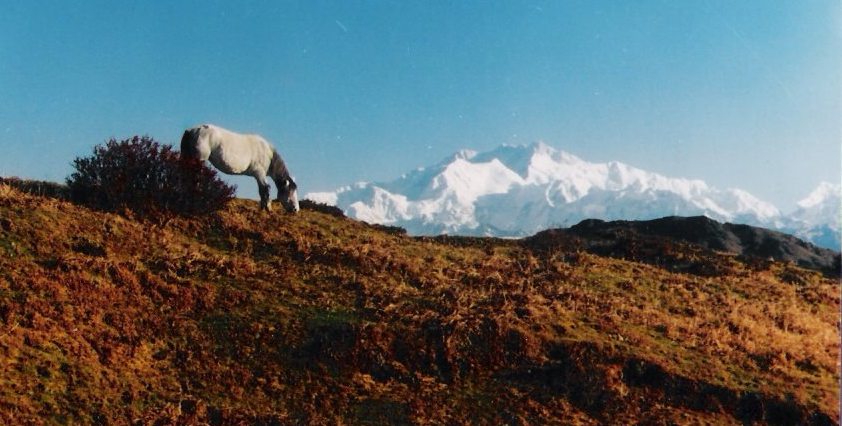 The first lap till Chitre
passes quite steeply uphill on a good stoned path through lush greenery
of pine, fir, birch forests and bamboo glades. It takes about an hour
and half to reach Chitre (2530 m). Crossing the Buddhist settlement of Chitre reach Meghma. The trail bifurcates at Meghma. The right uphill route leads to the trekkers hut at Tonglu (3070m) in India. The trail in the left passes through Nepal. The roads meet again at Tumling (in Nepal).
The first lap till Chitre
passes quite steeply uphill on a good stoned path through lush greenery
of pine, fir, birch forests and bamboo glades. It takes about an hour
and half to reach Chitre (2530 m). Crossing the Buddhist settlement of Chitre reach Meghma. The trail bifurcates at Meghma. The right uphill route leads to the trekkers hut at Tonglu (3070m) in India. The trail in the left passes through Nepal. The roads meet again at Tumling (in Nepal).
